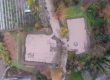
The archeological site of Dion in Pieria is one of the two pilot areas for testing and demonstrating the applications of the XENIOS system. Following discussions with the managers of the archaeological site and after studying its history and the landscape, it became evident that, in addition to the potential of threat due to wildfire hazard, flooding also represents a significant risk to the archaeological site and its visitors. Thus, the project partners included the risk of flooding among the natural hazards for which the XENIOS system will offer early warning to the site managers.
In order to be able to predict future floods in the archaeological site, it is necessary to understand the behavior of the basin upstream during significant rainfall events. This will be done through collaboration of the Institute of Mediterranean Forest Ecosystems of the Hellenic Agricultural Organization DEMETER with NCSR “DEMOKRITOS”, and with the contribution of the Center for Security Studies (KEMEA).


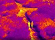
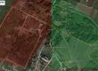
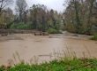
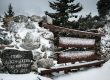
As there are no available runoff data though the site, it was decided to install a meteorological station within the fence of the site, and a radar water level sensor which will measure water level of the Vafyras river that runs through the archeological site and is responsible, together with the contributing torrent named Orlias, for the significant floods that have triggered serious flooding events and caused significant damages in the recent past. Thus, in June 2020, with actions of NCSR DEMOKRITOS, the meteorological station and the radar water level sensor shown in the photos below were installed and data started being measured, recorded and transmitted wirelessly, in preparation for the rainy season of the following autumn and winter.
The rights of the depicted monuments belong to the Ministry of Culture and Sports (Law 3028/2002).